When investigating emissions, it is essential to be thorough. Emission detection comes with many uncertainties. Researchers often utilize various methods to collect and analyze data on emissions including surface, airborne, and satellite. Surface and airborne methods are valuable because they accurately analyze and perform emission derivation, and they get precise readings. However, surface and airborne methods only cover a fraction of the Earth’s surface, and there are limitations on how frequently they collect data. Satellites provide continuous synoptic scale observations throughout the world; the only way to get global data coverage is with satellites. Satellite use is particularly advantageous when it comes to studying locations that are inaccessible to surface and airborne methods. Certain areas are often unavailable to research for logistical and geopolitical reasons.
While satellites are beneficial in many ways, they also have limitations because they observe areas with large footprints while averaging a lot of data. At BRI we often use a data fusion approach in our research meaning we combine data collected using AMOG (Automobile Trace Gas) Surveyor™ with data obtained using a satellite. Satellites collect data on a large scale while AMOG Surveyor collects fine scale in-situ data that is complementary to satellite data. To achieve validation of satellite data surface measurements must cover a significant number of pixels and move fast before the atmosphere changes. AMOG Surveyor is the perfect study platform to accomplish validation because it records fast, high-quality meteorology and trace gas concentrations at the fastest legal driving speed.
Satellite validation performed by AMOG Surveyor has helped lead to some notable findings. BRI participated in the GOSAT-COMEX Experiment (Greenhouse gases Observing Satellite-Carbon Dioxide and Methane Experiment (GCE)) campaign on multiple occasions. Results Include the discovery of legacy ammonia emissions at the Chino Dairy Complex in the Los Angeles Basin. Also, estimation of methane emissions from the Kern River oil field, and Poso Creek oil field, located northwest of Bakersfield.
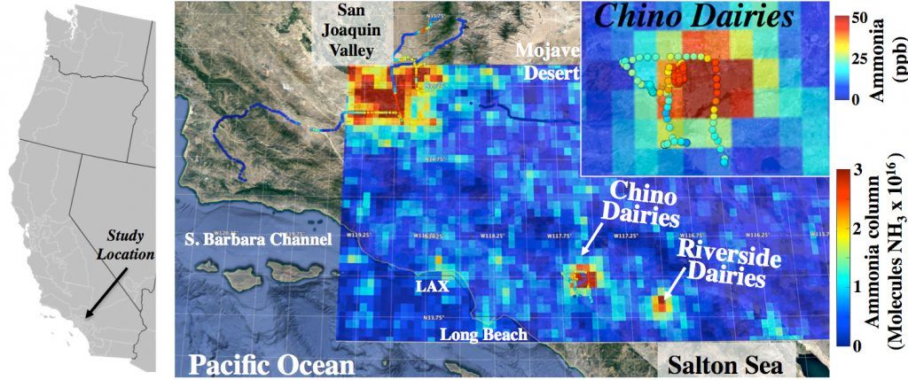
The Chino Dairy complex ammonia emissions from waste were able to be studied from space. Satellite data are from the IASI (Infrared Atmospheric Sounding Interferometer) instrument. Surface concentration in parts per billion (ppb) is from AMOG Surveyor and is shown as colored circles.
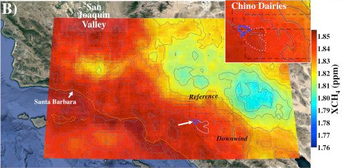
IASI (Infrared Atmospheric Sounding Interferometer) methane column concentration map (XCH4) for the Chino Dairy Complex (blue outline) and Chino reference and downwind analysis, labeled. Chino Dairy Complex methane plume outlined in dotted white line.
For more information on IASI (Infrared Atmospheric Sounding Interferometer) please visit https://www.eumetsat.int/website/home/Satellites/CurrentSatellites/Metop/MetopDesign/IASI/index.html