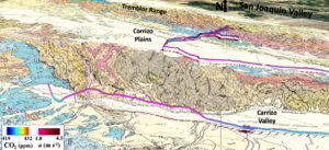
Last week (May 11), SISTER2 and the BRI team headed out to the Carrizo Plains to test sampling and survey protocols in preparation for a field campaign to study volcanic gas emissions in Death Valley for the NSF. Carrizo surveys focused on the San Andreas Fault and Elkhorn Fault in the Carrizo and Elkhorn Plains and the Recruit Pass Fault in the Tremblor Mtn. Range. The BRI team hypothesized that gasses from a petroleum reservoir around McKittrick (in the San Joaquin Valley) are migrating up the San Andreas Fault network, crossing right under the Tremblor Mountains.
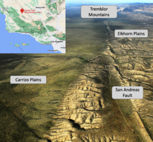 The Carrizo Plain stretches northwest from Cuyama in the Cuyama valley, tracing the path of the San Andreas Fault. On the plain’s northeast flanks lies the Temblor Range, separating the Carrizo Plains from California’s Central Valley (San Joaquin Valley). The Carrizo Plain is a grassland climate with few trees and an annual rainfall of around 9 inches yearly. Carrizo Plains was of particular interest due to the number of faults in the area. Visible surface fractures of the San Andreas Fault can even be seen along the eastern side of the plain near the base of the Temblor Range.
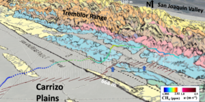
This figure shows methane (CH4) concentrations (ppm), wind speed (m/s), and relevant faults as solid or dashed lines, as well as different rock layers. Map is from Diblee 1973.
A first-look analysis shows methane emissions (CH4) from the San Andreas Fault and parallel faults in the San Andreas Fault Network (see figure above) and carbon dioxide.
The emissions likely are associated with a hitherto unknown geofluid system that connects the Carrizo Plains and the San Joaquin Valley. Faults provide a pathway for trace gasses and fluids to move or migrate from the source rocks deep below the surface to the atmosphere through the intervening rock layers. Faults create complicated damage zones in the rock that provide many pathways for trace gasses and fluids to pass, whereas solid rock is an impassable barrier. Also, fault motions reopen pathways that may get closed by for example deposition of tar and oil.
As there is no known tar or oil seepage in the Carrizo Plains, the migration pathways must filter out (for example, by a sand bed) liquid hydrocarbons. Air samples were collected in plumes using real-time data for analysis by the Blake Laboratory at the University of California, Irvine, to determine if other reservoir gasses – mainly hydrocarbons, accompany the methane and carbon dioxide – and if there are mantle gasses – the San Andreas Fault is very deep.
Mantle gasses may include radon, methane, helium, sulfur dioxide, carbon dioxide, and hydrogen sulfide. Ongoing analysis is investigating whether mantle gasses also are being emitted. It’s worth noting that water vapor is an important geothermal and volcanic gas; however, detection is challenging due to the heavy rains this winter in california and the recent super bloom, which would obscure any localized water vapor enhancement. Interestingly, these rains have replenished underground water sources, such as aquifers (Soda Lake is currently filled with water!). As a result, gas migration is enhanced as it rises as bubbles in the sediments. Bubbles are more efficient than diffusion – diffusion is all directions, whereas bubbles rise vertically. This means gasses can reach the surface more efficiently by following migration pathways.
The San Andreas Fault is a large north-south fracture in the Earth’s crust that spans approximately 750 miles across the state of California that marks the boundary between two massive tectonic plates: the Pacific Plate and the North American Plate,. THe San Andreas Fault is a “master” fault that comprises a greater, intricate fault network. The entire San Andreas fault system is more than 800 miles long and extends to depths of at least 10 miles within the Earth.
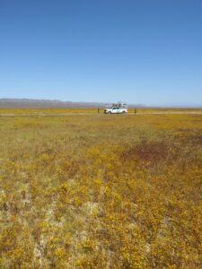
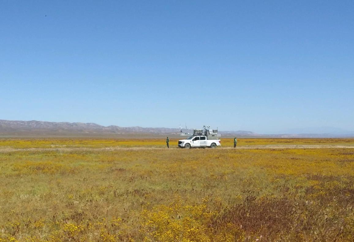
SISTER2 stopped to admire CA superblooms during the Carrizo Plains survey.
This BRI expedition had an unexpected perk – a super bloom. Every few years, during spring (March to late June), California experiences a super bloom where previously arid ground transforms into a vibrant field of flowers that stretch on and on to the horizon. Many local wildflowers, such as poppies and desert lilies, sprout all at once. Super blooms occurred in 2016, 2017, and 2019 and are now in 2023 due to a wet autumn and winter.
SISTER2 is an air quality laboratory in a 1-ton box, available for advanced gas leak detection and assessment. SISTER2 deploys by a pickup truck, boat, or trailer and measures 14 gasses, aerosols, and meteorology at up to highway speed. SISTER2 also features real-time visualization that informs how the BRI team drives SISTER2 – slowing down in areas of interest and redirecting to follow the emissions.
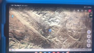
SISTER2 location is shown on the in-car monitor for real-time visualization.
Assessing Industrial Trace Gas Emissions: Fusion of Airborne and Surface Mobile in situ Observations with Targeted Trace Gas Sample Collection.
Assessing the impacts of industrial trace gas emissions requires accurate, robust, accessible, and economical assessment technologies on size scales of tens to hundred meters and for a broad spectrum of trace gasses. Airborne remote sensing data were acquired by the thermal infrared Mako sensor; in situ meteorology and trace gas measurements and air samples were collected by SISTER – Standard Instrumentation Suite: Truck Enabled forResponse for a refinery in the Port of Los Angeles. Remote sensing-CH4 emissions using SISTER winds were 69 g s-1 (2.18 Gg yr-1), within 10% of SISTER-derived emissions of 80 g s-1 (2.51 Gg yr-1). Ethane emissions from in situ analyzer data were at a 20:1 ratio to CH4 emissions. Canister-analyzer CH4 agreement was good (within 1-5%). Air samples alkanes and aromatics showed highly distinct chemical profiles (to C11) with significant elevation in the refinery plume compared to a nearby neighborhood (outside the plume), marine air, and to emissions from nearby oil wells. Combining these approaches allows for estimating emissions and exposure to a range of trace gasses, including those with health implications.
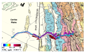
Figure shows air from the SJV into Carrizo Plains and into Cuyama – with CO2 and winds (u).
CO2 anomaly and winds.