BRI’s CEO Ira Leifer presents a talk for the 2020 AGU Fall Meeting on air pollution trends seen at the Ports of Long Beach and Los Angeles during the Covid-19 stay-at-home order. This presentation goes into depth on the results of recent air pollution surveys (in May and November 2020). Air pollution from traffic (trucks and freighters as well as local freeway sources) was expected to decrease as business activity slowed, but BRI expected to see no change in emissions from industry near the Ports.
Improvements in assessing health impacts can be improved by fusing epidemiology with mobile in situ air pollution surveys that allow targeted sample collection to map exposure in downwind communities. This study leverages Covid-19 emissions reduction at the Ports of Los Angeles and Long Beach (but not refinery emissions) to assess exposure changes in downwind neighborhoods that include significant disadvantaged communities as a basis for guiding long-term health studies.
Abstract of the study presented:
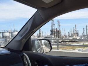
The Ports of Los Angeles and Long Beach are the busiest in the western hemisphere and are situated amid extensive coastal industrial activities include refining, petroleum production, coke production, and water treatment. Heavy-duty diesel trucks transport the vast majority of containers on area highways, contributing diesel particulates matter (PM) and volatiles to downwind pollution. Covid-19 economic damage dramatically reduced US air pollution from port area traffic and commercial activities improving downwind community air quality, though refining and other commercial emissions continue. The resulting pollution profile shifts have significant health implications.
We demonstrate how repeat in situmobile field data surveys and targeted survey canister sampling provide pollution profiles for sources and in downwind communities. Combined with long-term fixed station air pollution and satellite and airborne remote sensing can map potential exposure in downwind neighborhoods, guiding epidemiology study development and analysis.
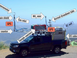
Repeat in situ Standard Instrumentation Suite: Truck Enabled for Response: SISTER™ surveys in 2020 during the Covid-19 shutdown in TMOG (Truck MObile trace Gas) Surveyor were conducted in the Port area for comparison with similar summer 2019 data. SISTER measures 13 trace gases, meteorology, and aerosol vertical profile and size spectra at up to highway speed. Real-time visualization enables targeted sample collection (60+ gases analyzed). A June 2020 (and the 2019) survey was concurrent with port area airborne thermal remote sensing by Mako.
Key findings were strong emissions from remaining commercial activities, dramatic NOx decreases and significantly different alkane/alkene/alkyne C1-C11profiles for port activities, traffic, refining, wastewater, calciner, and downwind neighborhoods. Inverse plume-models were validated against remote sensing data and then fused with sample composition to derive a broad spectrum of trace gas emission factors. Forward modeling, validated by comparison with satellite and permanent station data, allows derivation of exposure maps to form a basis for assessing potential health implications and guiding epidemiology.
© 2021 Bubbleology Research International. All rights reserved.
Related Articles
-
A Look Inside BRI’s Standard Instrumentation Suite: SIS™
-
New Report: Field validation of a combined thermal infrared and visible remote sensing method using oil from a natural marine seep
-
Seep Science: Tar on the Beach
-
BRI proposes study to understand the implications of air pollution from the Ports of Los Angeles and Long Beach on downwind community health